|
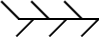
Cold front
The leading edge of an advancing colder air mass. Its passage
is usually marked by cloud and precipitation, followed by a drop
in temperature and/or humidity.
|

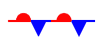
Warm front
The leading edge of an advancing warmer air mass, the passage of
which commonly brings cloud and precipitation followed by increasing
temperature and/or humidity. |

Occluded front (or 'occlusion')
Occlusions form when the cold front of a depression catches up with
the warm front, lifting the warm air between the fronts into a narrow
wedge above the surface. Occluded fronts bring cloud and precipitation. |
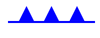
Developing cold/warm front (frontogenesis)
Represents a front that is forming due to increase in temperature
gradient at the surface.
|
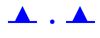
Weakening cold/warm front (frontolysis)
Represents a front that is losing its identity, usually due to rising
pressure. Cloud and precipitation becomes increasingly fragmented.
|
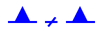
Upper cold/warm front
Upper fronts represent the boundaries between air masses at levels
above the surface. For instance, the passage of an upper warm front
may bring warmer air at an altitude of 10,000 ft, without bringing
a change of air mass at the surface.
|
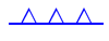
Quasi-stationary front
A stationary or slow-moving boundary between two air masses. Cloud
and precipitation are usually associated.
|
Isobars
Contours of equal mean sea-level pressure (MSLP), measured in hectopascals
(hPa). MSLP maxima (anticyclones) and minima (depressions) are marked
by the letters H (High) and L (Low) on weather charts.
|

Thickness lines
Pressure decreases with altitude, and Thickness measures the difference
in height between two standard pressure levels in the atmosphere.
It is proportional to the mean temperature of this layer of air,
so is a useful way of describing the temperature of an airmass.
Weather charts commonly show contour lines of 1000-500 hPa thickness,
which represent the depth (in decametres, where 1 dam = 10 m)
of the layer between the 1000 hPa and 500 hPa pressure
levels. Cold, polar air has low thickness, and values of 528 dam
or less frequently bring snow to the UK. Conversely, warm, tropical
air has high thickness, and values in excess of 564 dam across
the UK often indicate a heatwave.
|
Trough
An elongated area of relatively low surface pressure. The troughs
marked on weather charts may also represent an area of low thickness
(thickness trough), or a perturbation in the upper troposphere (upper
trough). All are associated with increasing cloud and risk of precipitation.
|
Convergence Line
A slow-moving trough, which is parallel to the isobars and
tends to be persistent over many hours or days. They are quite common
in cold northerly outbreaks down the Irish Sea, affecting west Wales,
Devon and Cornwall in particular, but can be found in other areas
also. This convergence line can gives hours of persistent precipitation
over very localised areas, whilst a few miles down the road it is
relatively dry, leading to some heavy snowfall/rainfall. In summer
the convergence lines are not as easy to forecast, but then can
still occur due to sea-breeze convergence, and are over the land,
whilst in winter they are over the sea.
|
|