The above files contain the latest updated three-day current prediction. The data have been compressed using the compression programmes bzip2. The BSH generates the data by means of a numerical prediction model which has been developed for up-to-date predictions of water levels and storm surges as well as drift and dispersion forecasts, e.g. in connection with oil spills. The model computes daily predictions of tidal currents, wind induced currents, and baroclinic currents. The computed surface current data are average values in the uppermost 8 metres of the water column.

Legal notice
The BSH does not guarantee the functioning, completeness, accuracy or up-to-dateness of the predicted current data. Moreover, it will not be held liable for any technical failures or malfunctioning resulting from errors in data files or in the configuration of formats.

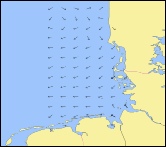
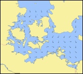
BSH current grib files use the Grib 2 format which is not yet accepted by every grib file viewer.
Amongst others, they can be used with qtVLM or OpenCPN but only in version 4.2.1706 or above

NORTHSEA 48.5°N/04.0°W  to 60.0°N/010.0°E  grid 6 nm, 1h GERMAN BIGHT 53.3°N/07.5°E   to 54.5°N/09.3°E grid 1 nm, 0.5h BALTIC SEA 52.0°N/010.0°E  to 68.8°N/030.0°E grid 6 nm, 1h TIDAL CURRENTS PROVIDED BY BSH - GERMAN HYDROGRAPHIC AGENCY - www.bsh.de WESTERN BALTIC 53.2°N/009.5°E to 56.4°N/014.8°E grid 1 nm, 1h Download as grib file